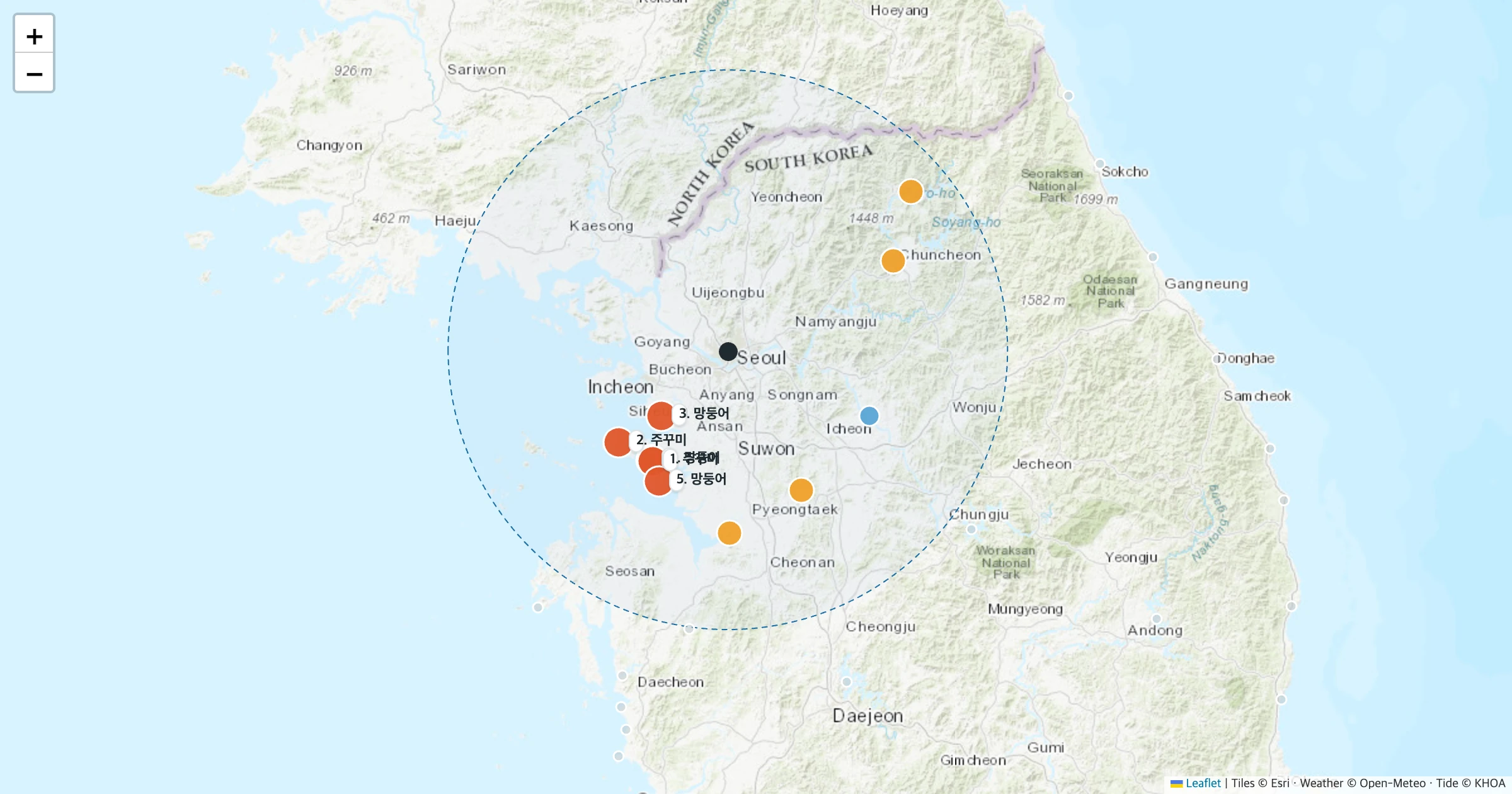
Where Should We Go Fishing Tomorrow? — A Web App That Uses Tides and a Map to Pick Where, When, What and How for Beginners Who Know Neither the Spot Nor the Species
There are plenty of tide apps, catch report apps and closed-season apps. But most of them only work once you pick a region, a target species or a fishing style. A total beginner who wants to try fishing tomorrow needs the opposite: enter where you start and the date, and get places, times, species and rigs. So I built a web app that shows exactly that on a map. It computes tides for 56 spots across Korea from KHOA harmonic constants, overlays wind and wave forecasts with each species' season and closed season, and gives a rough probability of catching at least one fish during your stay. The computed high and low water times were 14 minutes off KHOA predictions on average; a public sea level forecast (Open-Meteo) was 34 minutes off. Shaking each species' base assumption by 0.5 to 2 times left the top five picks from Seoul unchanged 69% of the time.
Friends are chatting and someone says, "Want to go fishing tomorrow?" Everyone's in. And then it stalls. Where do we go? What do we catch? What time? Do we even need rods?
There are plenty of fishing apps. Apps that tell you the tides, apps for sea weather, apps that collect the catch photos boat captains post, apps that list closed seasons. But open most of them and the first screen asks: Which region? Which species? Rocks or boat? If you know that, you are already an angler.
This time I flipped the question. Enter only where you are starting from and the date, and a web app picks places, times, species and rigs for you on a map.
What I set out to do
- Map out what fishing information services in Korea and abroad tell you, and what they ask you to decide first.
- Look at what tides (mulddae) are and how much they differ by region, in numbers.
- Compute tides myself from the harmonic constants published by the Korea Hydrographic and Oceanographic Agency (KHOA), and check them against official predictions.
- Collect sea and freshwater fishing spots across Korea and beginner-friendly species, with closed seasons, minimum sizes and access restrictions.
- Build an engine that combines season, tide phase, current, time of day, weather and difficulty into a "rough probability of catching at least one fish during your stay."
- Turn it into a map web app, and measure how much that probability moves with the assumptions.
The research was split between two AI agents: one on apps, regulations and tide concepts, the other on spot coordinates, species seasons and tide data. I had the legal items checked against the original annex PDFs on Korea's National Law Information Center, and coordinates taken only from Wikipedia and OpenStreetMap. Anything that could not be confirmed was marked unconfirmed. The engine, web app and experiments were also built and run by an AI agent.
Lots of fishing apps, lots to know first
I sorted the services commonly used in Korea by "what they tell you" and "what you must decide first."
| Service | What it tells you | What you must decide first |
|---|---|---|
| Muldae-wa Nalssi (ATCultures) | Tides, wind, waves and water temperature for about 1,560 points | Region (point) |
| Badatime (INTERBIRD) | Tide tables for about 1,420 areas, about 2,000 fishing points and 300 boat points | Region |
| KHOA Sea Fishing Index | Species index (5 levels) by point and time slot | Point, rocks or boat |
| Eosin (SGMA) | Bite probability by target species, point picks, boat booking | Date, region, target species |
| Booking platforms (The Fishing, Mulban Gogiban, etc.) | Boat booking, catch reports posted by captains | Region, species, boat |
Tide apps tell you precisely "the tide where." What to catch is up to you. Eosin goes a step further and gives bite probabilities by species; in the company's words, "just pick a date and a target species" and it recommends points. Handy for anglers, but for a beginner that "target species" is the first wall.
There is a public option too. KHOA's Sea Fishing Index scores each point and species using water temperature, tides, waves and current speed. Since March 2025 it has been a free API on Korea's public data portal (10,000 calls a day on a development account). But it too needs you to choose the point.
Abroad, Sweden's Fishbrain is the biggest. It says it has 20 million catch logs. It mixes those with air temperature, pressure, moon phase and water temperature to sell a paid feature called BiteTime that predicts "when" each species bites. It also supplies data to the "Places to Fish" map of the US Recreational Boating & Fishing Foundation (RBFF). It is the closest case to a beginner-oriented "where." But it does not pick "what, given tomorrow's conditions."
The "solunar theory" many apps use is worth a note. In 1926 John Alden Knight of the US laid out when fish are active based on the moon and sun, and published tables in 1936. Yet a 2023 paper that tested it against North American freshwater trout catch records (Quigley et al., SN Applied Sciences) found no relationship between catch rates and solunar values, moon phase or moon brightness. The only meaningful predictor was air temperature. Many apps that advertise "bite times" lean on these tables.
Tides: 8.6 m in Incheon, 16 cm in Pohang, on the same day
The first word you run into in Korean sea fishing is mulddae, the tide day. "It's 9-mul, the water's strong." "It's jogeum, the water's dead." The names are attached to lunar calendar days. As the moon waxes and wanes, the height difference between high and low water (the tidal range) grows and shrinks on a 15-day cycle. The largest is spring tide (sari), the smallest neap tide (jogeum).
According to KHOA, spring tide comes not on the full or new moon itself but two or three days later. That makes the naming a little tangled. The West Sea uses a 7-step system and the South and East Seas an 8-step system, so the same day is called one step apart. October 28, the day this post is about, is the 18th day of the 9th lunar month: 9-mul on the west coast, 10-mul on the south coast.
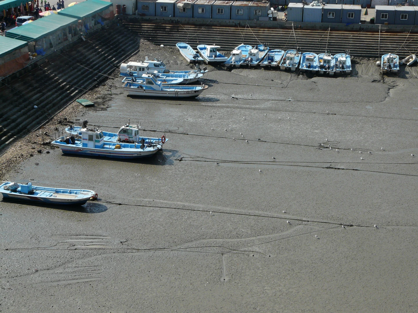
Siheung, Gyeonggi, October 2014. The boats have settled on the mudflat at low tide. Photo: Piotrus, CC BY-SA 3.0, Wikimedia Commons
But the same tide-day name means very different water movement in different seas. I computed the tidal range for October 28 from KHOA's harmonic constants.
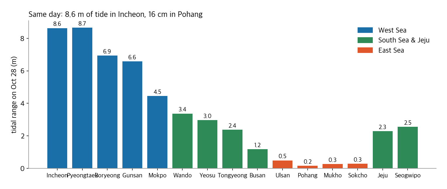
Incheon and Pyeongtaek rise and fall more than 8.6 m in a day, about three apartment floors. Pohang moves 16 cm. On the west coast the tide is essentially "when the mudflat is exposed and when it floods," so it decides when you can fish at all. On the east coast, waves and water temperature matter more than the tide. The same "9-mul" means different things on the two coasts.
Computing the tides myself
Tide apps display KHOA's predictions. The official tide prediction API is on the public data portal but needs an API key. This web app had to run in anyone's browser without a key, so I decided to compute the tides myself.
A tide can be seen as the sum of waves with different periods. The largest are M2, every 12.42 hours from the moon; S2, every 12 hours from the sun; and K1 and O1, once a day. Each port has its own height (amplitude) and delay (phase lag) for each period. KHOA publishes these for 87 reference ports on the public data portal as "harmonic constants." Add the four together and you get the water level at that port.
I checked against the official predictions for those dates. KHOA's old tide page is gone and the new API needs a key, so I used Badatime's tide tables, which state they are "provided by KHOA," as the reference. I compared 69 high and low water times at 9 ports on October 28 and 29, and also compared the same times with the sea level forecast from Open-Meteo, a public weather API.
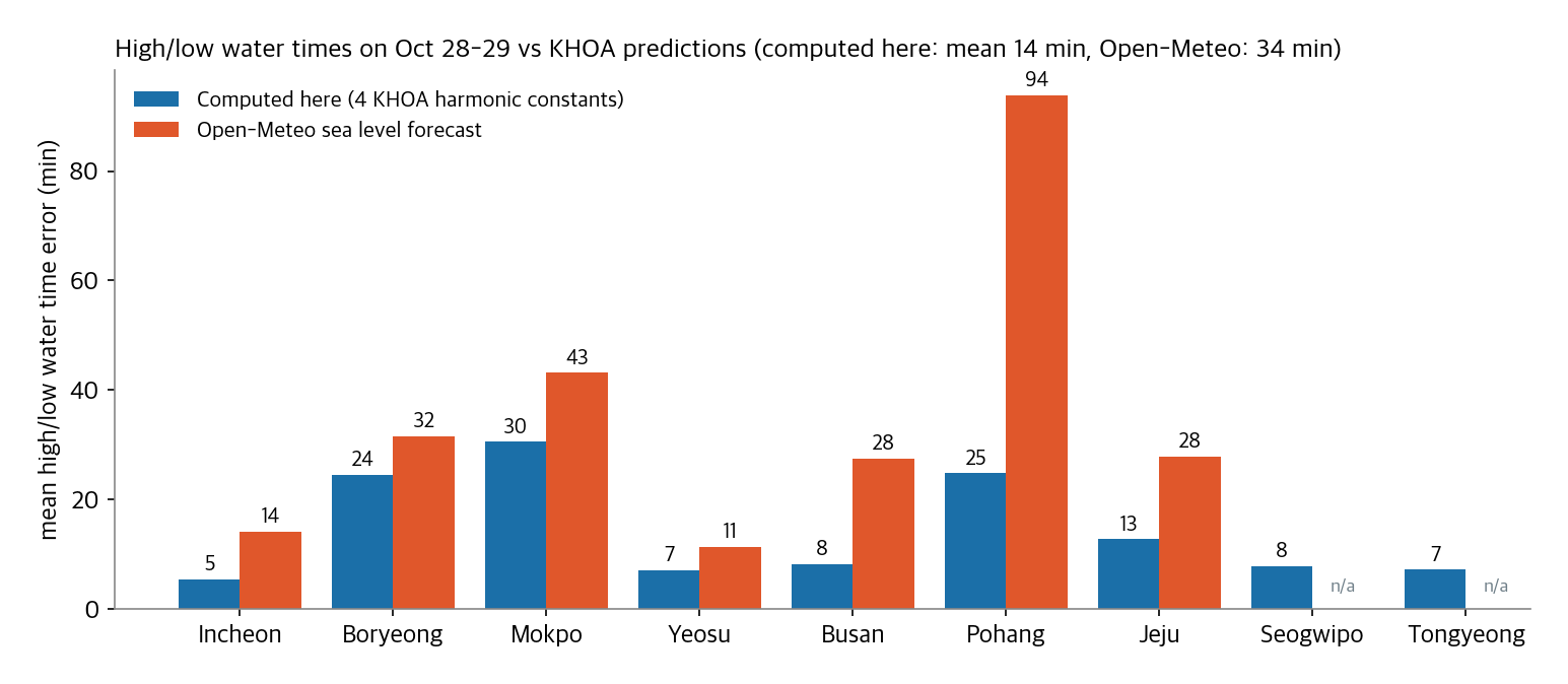
Adding just four harmonic constants gave a mean high/low water time error of 14 minutes, with a worst case of 51 minutes. Open-Meteo averaged 34 minutes and was off by up to 2 hours 53 minutes in Pohang. Open-Meteo's sea level comes from a global model computed on a grid over the whole ocean, so it does not follow narrow bays or channels between islands well. For heights, my computation was off by 20 cm on average and up to 69 cm in Mokpo. In shallow, island-studded waters like Mokpo, the smaller periods beyond the main four become large.
So the web app computes tides itself and gets only wind, waves and rain chance from Open-Meteo. The screen says "about ±30 min."
What you can't keep, where you can't go
What beginners know least is the rules. Korea's Fisheries Resources Management Act sets, by species, periods when catching is prohibited (closed seasons) and sizes you cannot keep (minimum sizes). Since 2020, recreational anglers also pay a fine for violations (800,000 won at the time).
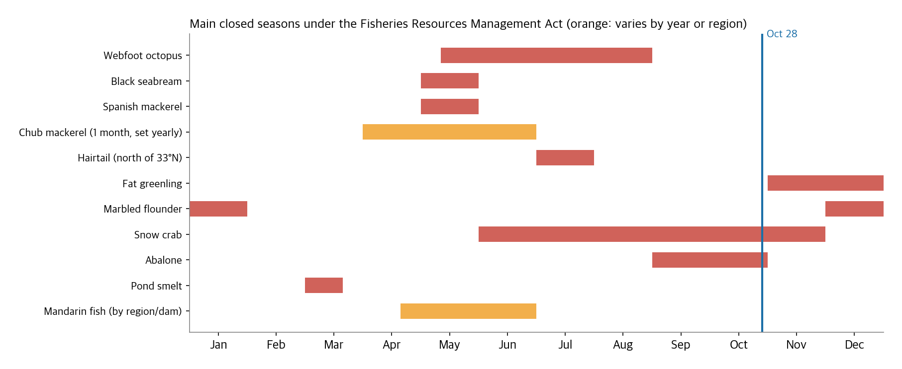
As of October 28, snow crab is in its closed season, and fat greenling closes four days later on November 1. Minimum sizes prohibit keeping black seabream of 25 cm or less, Korean rockfish of 23 cm or less and olive flounder of 35 cm or less. The research also turned up wrong summaries online. Some posts say "the black seabream closed season was abolished," but the annex revised in June 2026 still has the May closure. Conversely, golden cuttlefish dropped off the annex after a 2023 revision.
There are rules about places, too. Coast guard stations are designating more breakwater tetrapod areas as "restricted access zones" because of frequent accidents. Entering without permission can bring a fine of up to 1 million won. The East Sea coast guard said accidents fell about 32% below the five-year average after it restricted tetrapods in its area in 2025. Of the spots in the app, Gyeokpo Port, Wido Port, Wando Port's new harbor and Samcheok Imwon Port's east breakwater were confirmed restricted from sources and carry an "access restricted" tag. Restrictions at other spots should be rechecked against coast guard notices.
How it chooses
What the app does is simple. It pairs all 56 spots (47 sea, 9 freshwater) with 24 species, splits the day into 48 half-hour slots and scores each slot.
- Season. How well that species bites in that sea in that month, from 0 to 3. I set these from the consensus in fishing magazines and articles. West Sea webfoot octopus, for example, is 3 in September and October and 2 in November.
- Current. From the computed water level, how much the height changes in 30 minutes, divided by the day's fastest change. Species said to like "moving water," such as black seabream, goby and mackerel, score higher when it is large; species where "weak currents make the rig easier to work," such as boat-fished webfoot octopus and rockfish, score higher when it is small.
- Spring and neap. The day's range placed between that port's spring and neap ranges, as 0 (neap) to 1 (spring). Black seabream gets more toward spring, webfoot octopus toward neap.
- Time of day. From computed sunrise and sunset, species that like dawn and dusk score more within an hour and a half of them. Night species such as black rockfish and conger score at night.
- Weather. Big cuts at wind of 9 m/s or more, effectively zero at 12 m/s. Wave cuts start at 1.5 m for boats, 1.2 m for rocks and 2 m for breakwaters.
- Difficulty. Easy species like goby and webfoot octopus stay as is; hard ones like black seabream and sea bass are cut to under half.
- Closed season. Zero.
I should say up front that the tide preferences rest on weak evidence. "Fish bite on the rising and falling tide" is widespread among anglers, but the research found no study testing it on Korean target species, and foreign studies sometimes found opposite results by species. So the tide scores reflect the folklore but with small swings.
Multiply these scores by a base bite rate for each species to get expected fish per hour in each slot. The base rate is my assumption of how many fish a beginner catches per hour from a breakwater or rocks at peak season in good conditions: 1.5 for goby, 1 for chub mackerel, 0.4 for webfoot octopus, 0.05 for black seabream and so on. On a boat the captain finds the fish, so I multiplied webfoot octopus and golden cuttlefish by 6 and rockfish by 5.
These numbers are not measurements. They are assumptions set from folklore, not fitted to catch records. With tens of millions of catch logs, like Fishbrain, you could fit them to data. I had no such data.
Sum the expected catch over your stay (3 hours by default) and convert it to "the probability of catching at least one." Treating bites as independent, that is 1 − e^(−expected). I also compute the probability if the assumptions were half or double. That is why the screen shows "99%" with a smaller "91–100%" underneath. The three consecutive hours with the largest expected catch are shown as the "best window."
Results for tomorrow (October 28)
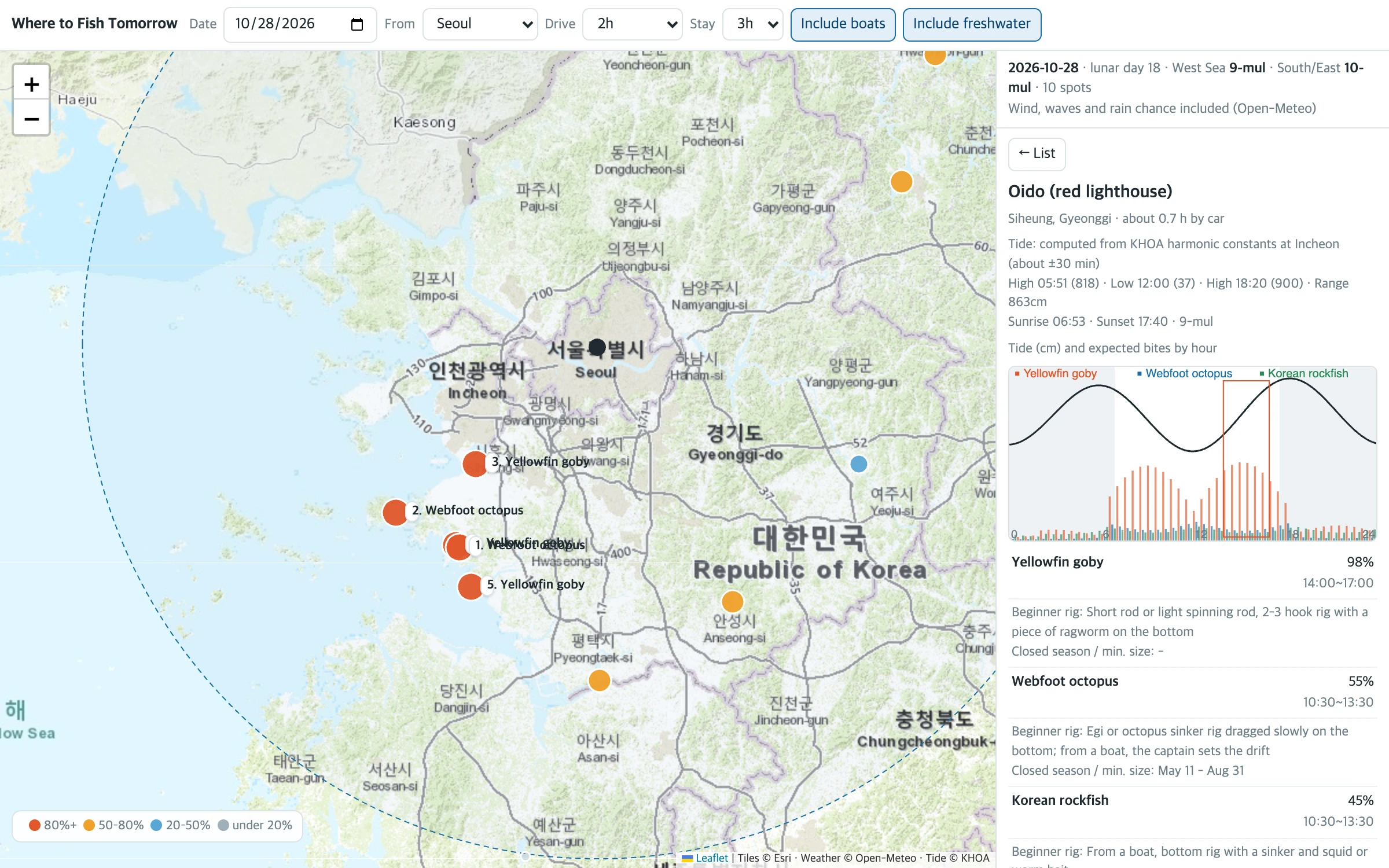
I ran it with the forecast for tomorrow fetched on the night of October 27. For each city, the top pick within a 2-hour drive (straight-line distance × 1.3 at 70 km/h).
| From | Top pick | Best window | Rough probability |
|---|---|---|---|
| Seoul | Jeongok Port, Hwaseong: webfoot octopus by boat | 10:30–13:30 | 99% (91–99%) |
| Seoul (no boats) | Oido, Siheung: goby | 14:00–17:00 | 98% (85–98%) |
| Daejeon | Hongwon Port, Seocheon: webfoot octopus by boat | 09:00–12:00 | 99% |
| Gwangju | Gukdong Port, Yeosu: webfoot octopus by boat | 15:00–18:00 | 99% |
| Busan, Daegu, Ulsan | Bangeojin Port, Ulsan: chub mackerel by boat | 16:30–19:30 | 99% |
| Gangneung | Dongmyeong Port, Sokcho: chub mackerel by boat | 05:30–08:30 | 99% |
| Jeju | Seogwipo Port: hairtail by boat | 05:30–08:30 | 99% |
Webfoot octopus in the west, mackerel in the east, hairtail on Jeju. It matches the picture in late-October fishing articles. From Seoul without boats, Oido goby rises to the top, from 2 to 5 p.m. while the tide is coming in. High water at Incheon is at 18:20, so that is when the water rises.
Weather got in the way too. Of 47 sea spots, 11 had a warning for wind of 9 m/s or more or high waves sometime during the day tomorrow. Seongsanpo Port and Chagwido on Jeju had wind above 12 m/s, and Chagwido also had 1.9 m waves. The app picks the "best window" to avoid those hours, and if a warning remains it adds "strong wind" or "high waves."
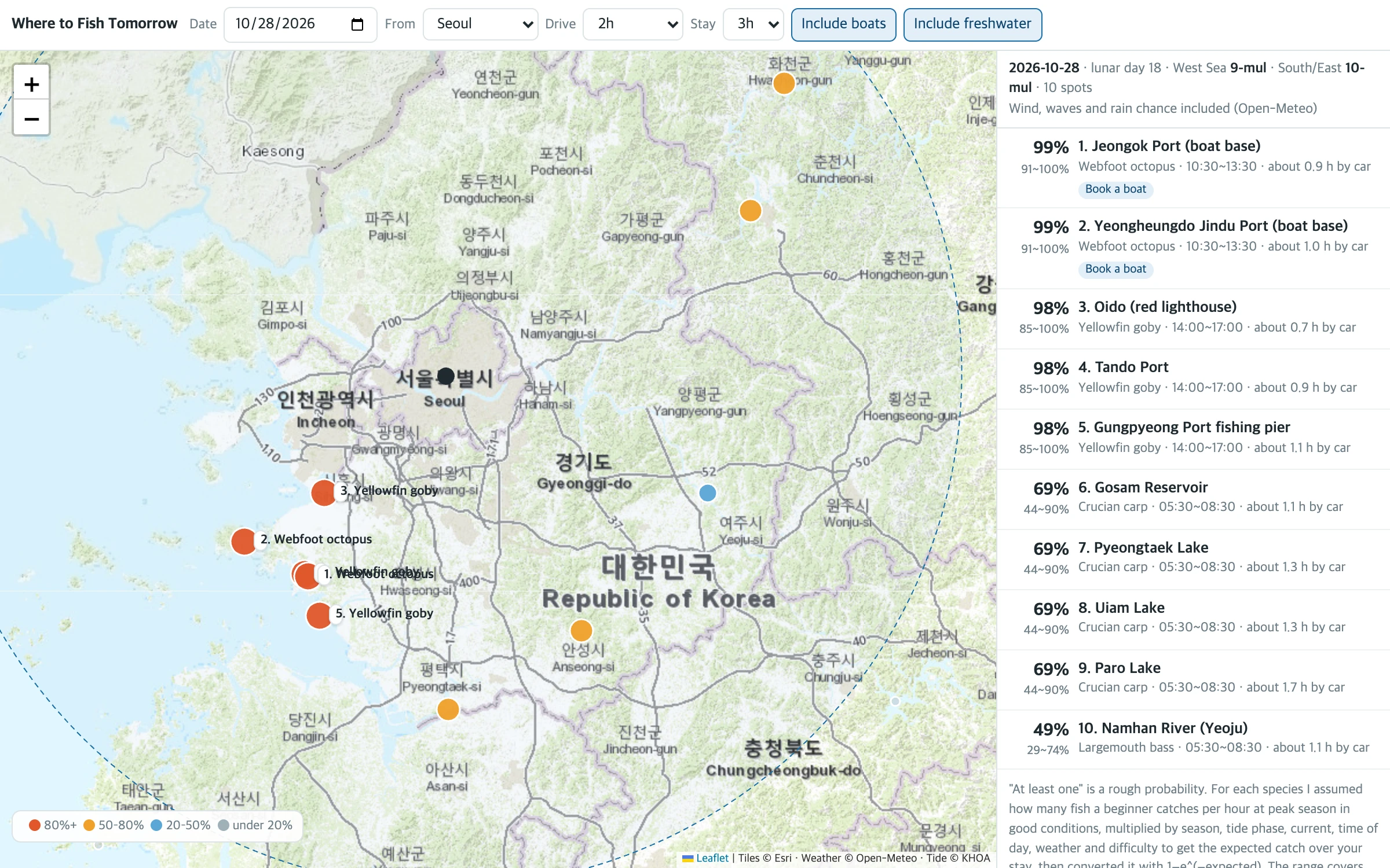
Too many 99s
One thing jumps out right away. Almost everything at the top is 99%. In season, a beginner who spends three hours fishing for goby or mackerel, or for webfoot octopus on a boat, usually catches at least one. So the "at least one" probability fills up quickly. With my first assumptions it was worse: almost every spot within two hours of Seoul came out 100%. Only after cutting the base rates to less than half did gaps like reservoir crucian carp at 69% and Namhan River bass at 49% appear.
Running the next 30 days the same way makes this saturation clearer.
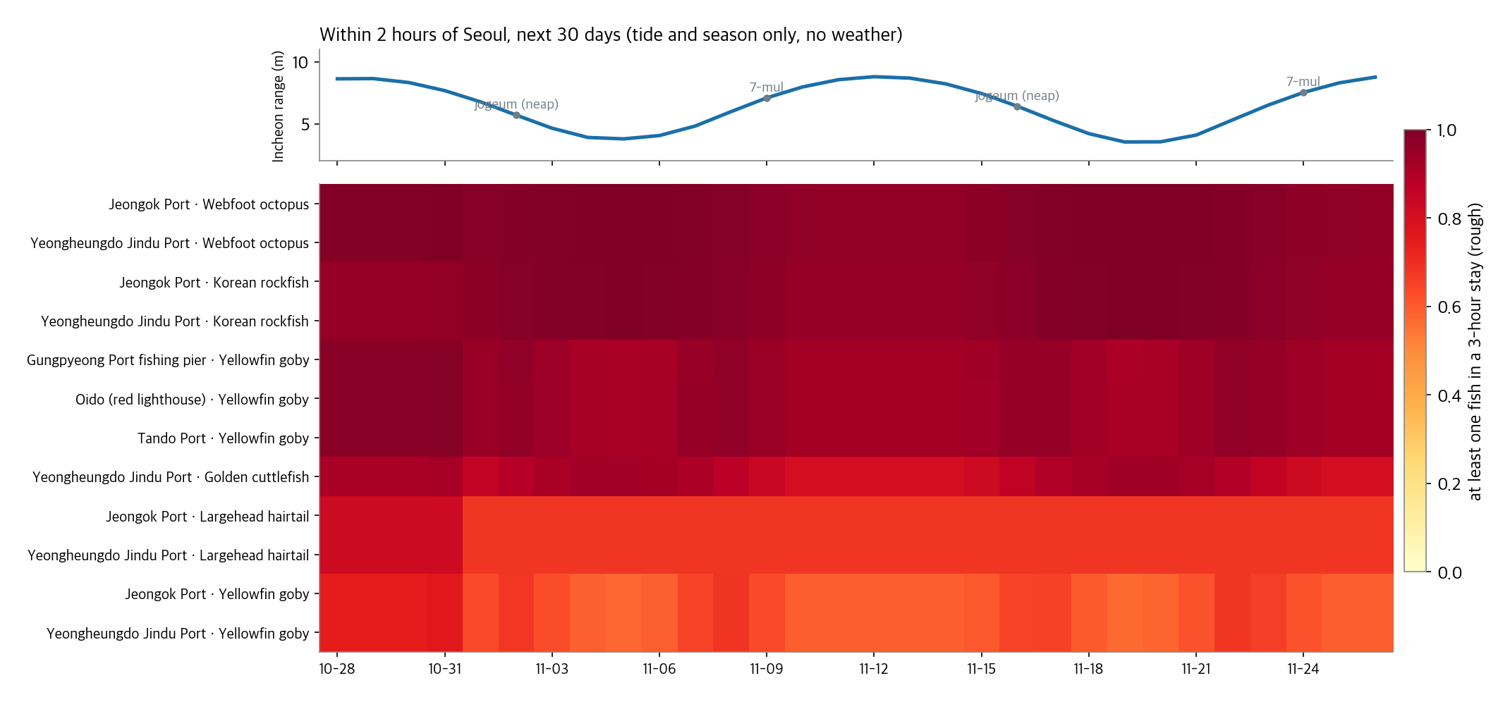
The tidal range more than doubles and halves on a two-week cycle, yet the colors barely move. Goby fades slightly around neap tides, and that's about it. The model gives the tide much less sway than the season, on purpose, so as not to put much weight on weak folklore. The cost is that this probability does not separate "which day is better" well. The app is more useful for choosing "what time" within a day.
If the assumptions are wrong
Since the base bite rates are assumptions, I measured how much the ranking changes if they are wrong. I set each of the 24 species' values to a random factor between 0.5x and 2x and reran it 200 times, comparing the ranking within two hours of Seoul.
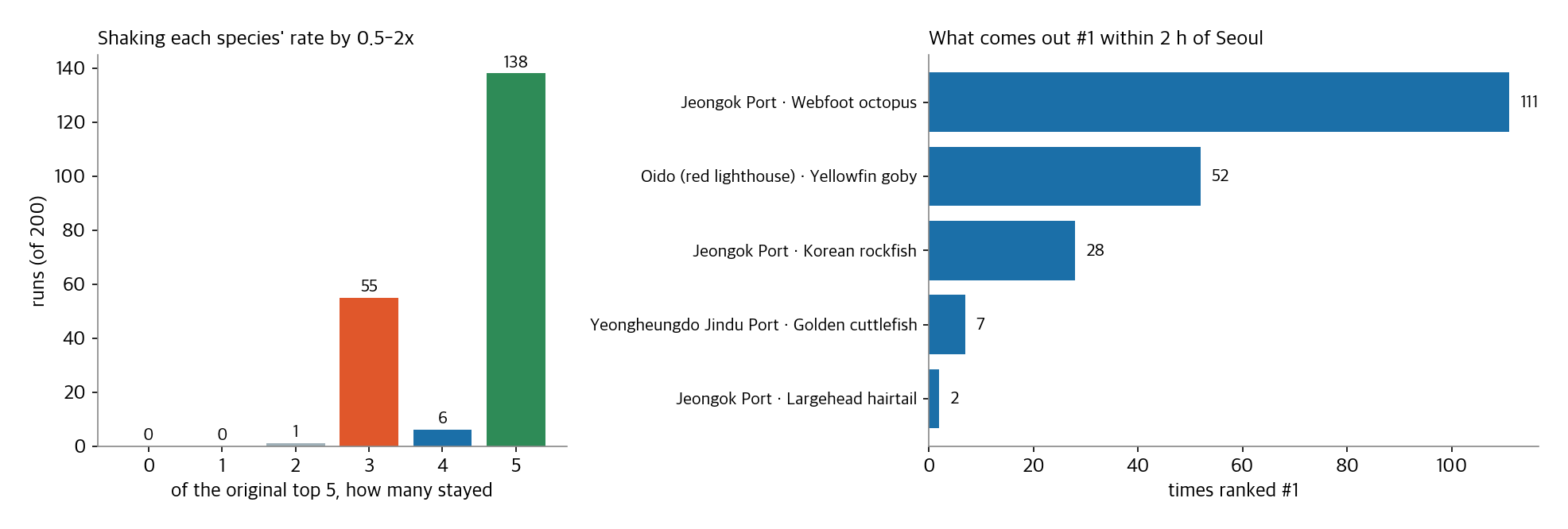
The top 5 stayed the same in 138 of 200 runs (69%). The #1 pick stayed the same 111 times (56%); otherwise it switched to Oido goby or Jeongok rockfish. Even when it switched, the big picture held: "west coast, octopus or rockfish by boat, or goby from a breakwater." The individual numbers are hard to trust, but the answer about what to fish for and which way to drive holds up fairly well.
Try it
On a narrow screen, open it in a new window. Change the date and it recalculates with that day's tides and weather. Dates more than 16 days out are computed from tides and season only, without a forecast, and it says so. Turn off "Include boats" to drop places that need a boat booking and keep only what you can do from breakwaters, rocks and beaches.
Where it went wrong
- I tried to use a public sea level forecast as is. At first I planned to get Open-Meteo's sea level along with wind and waves, since it returns many places in one request. Checked against the reference, it was off by up to 2 hours 53 minutes for high water in Pohang. Entering Pohang's coordinates also snapped to an offshore grid cell to the northeast (36.21°N) rather than one near the coast. I switched to computing tides myself.
- I misread the harmonic constants' "phase lag." KHOA's phase lags are referenced to 135°E. Plugging them straight into Korean clock time put high and low water off by 50 minutes on average. Switching to Greenwich-based astronomical arguments plus 135 degrees brought it down to 14 minutes.
- Every probability was 100%. With the base rates I first chose, nearly every place near Seoul came out 100%. I had set them by the standard of someone who fishes well at peak, like "4 goby an hour." I lowered them to a beginner's level and applied multipliers only for boats. Easy species still stick at 99%. That limit remains unfixed.
- It drove from Jeju to Jindo. Counting travel time by distance alone put Jindo's Seomang Port within two hours of Jeju. That route crosses the sea. I changed it so you cannot drive between Jeju and the mainland. Ferry time to islands (Yokjido, Wido and so on) is not counted yet.
- Some spots had no coordinates. Of the 60 spots researched, Magumpo, Samcheonpo, Mijo and Jisepo ports were dropped because no confirmed coordinates were found. Hupo, Jukbyeon and Mukho use the coordinates of nearby train stations rather than the ports, and are tagged "approx. location."
- I could not collect any parking, restroom or railing information for the spots. It is the most important information for beginners, and none of it could be confirmed from sources.
Why this works in one click
Because the ingredients are all public. KHOA publishes harmonic constants, the National Law Information Center publishes closed seasons, and Open-Meteo provides weather, all for free. The positions of the moon and sun come from astronomical formulas. Machines are good at stitching these together. Scoring 56 spots × 24 species × 48 slots and ranking them takes less than a second in a browser.
What does not work in one click is the base of the probability. "How many fish a beginner catches per hour" is not published anywhere. Catch photos from fishing boats, trip reports in angler communities and the fisheries ministry's fishing boat catch statistics are scattered around, but there is no record that lines up "who, where, how many hours, how many fish." Doing what Fishbrain does with 20 million logs in Korean waters would require building that record first. Until then, this app's probability is a number that points a direction, nothing more.
If you want to try this
- Compute tides from harmonic constants. KHOA's constants for 87 reference ports are on Korea's public data portal. Even four of them get high and low water times within about 15 minutes on average. If you need more accuracy, get a key and use the official tide prediction API.
- Check the reference longitude of the phase lags first. With the same formula, plugging in the wrong reference time puts you off by 50 minutes.
- Show probabilities as ranges. A single probability built on assumptions reads like a guarantee at 99%. Attach the range for when the assumptions are wrong.
- Check rules in the original text. Summaries like "closed season abolished" were sometimes wrong. The decree's annex PDFs are on the National Law Information Center.
- Mark access restrictions on the map separately. Tetrapod restrictions keep expanding. Check coast guard notices regularly.
What it can't do
- The probability is not fitted to catch records. Base bite rates and tide preferences by species are assumptions from folklore.
- The tide effect is kept small, because the evidence is weak. So it does not tell "which day is better" well.
- There are only 56 spots. Compared with Badatime's 2,000+ points, these are just representative locations. Within a port, which end of which breakwater you stand on matters more, and that information isn't here.
- It ignores water temperature. For species that follow temperature, like mackerel and yellowtail, it could be a better signal than the season.
- It can't book boats. It only adds a "Book a boat" tag. Departure times and spots differ by operator.
- Travel time is a rough guess. Straight-line distance × 1.3 at 70 km/h, ignoring traffic and ferries to islands.
- It does not judge safety. Wind and wave warnings come from forecast values only. Wear a life jacket and do not go alone at night.
Still, it gives you a starting point. A conversation that used to stop at "Want to go fishing tomorrow?" can go on to "Let's go to Oido at 2 p.m. for goby, and pick up some ragworm on the way." And if you note how many you actually caught, that becomes the first data to fix this probability.
If you enjoyed this, please leave a comment.
Sources
- Korean services: Muldae-wa Nalssi App Store, Badatime App Store and tide guide, Eosin App Store and Venture Square, KHOA Sea Fishing Index public data portal, booking linked to the government "Naksihae" app Dailian 2020-10-22
- Services abroad: Fishbrain, BiteTime, solunar test Quigley et al. 2023, SN Applied Sciences, solunar history Texas Saltwater Fishing Magazine
- Tides: KHOA FAQ, Marine Environment Information Portal on tidal range, harmonic constants KHOA reference port constants (public data portal), tide prediction API public data portal, reference high/low water Badatime tide table (provided by KHOA)
- Rules: Enforcement Decree of the Fisheries Resources Management Act Annex 1, closed seasons and Annex 2, minimum sizes, Inland Fisheries Act decree Annex 1, fines for anglers Dailian, restricted access zones Newsis 2026-03-05 and Segye Ilbo 2026-07, fishing license under review Herald Economy 2025-06-09
- Weather: Open-Meteo (Forecast and Marine API, CC BY 4.0), map Esri World Topographic Map, Leaflet
- Spot coordinates: values looked up on Wikipedia and OpenStreetMap Nominatim. Species seasons and tide preferences are consensus values from fishing magazines and news articles
- The tide computation, recommendation engine, web app, 30-day calendar, assumption shake-up and charts were all made by the experiments in this post
Image credits
- Siheung port photo: Wikimedia Commons, File:Siheung October 2014 31.JPG, Piotrus, CC BY-SA 3.0
- All other figures and screens were made by the experiments in this post. Map background by Esri
