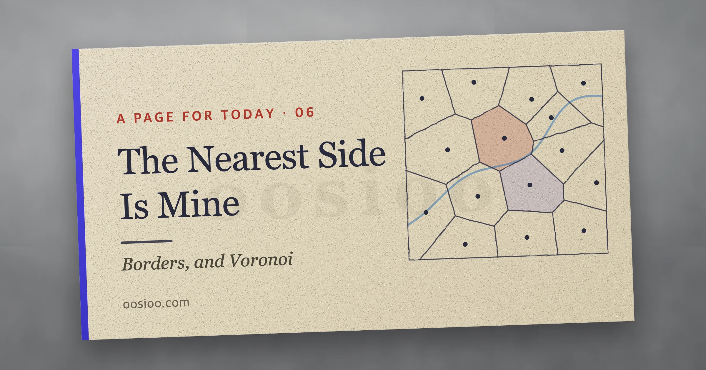
The Nearest Side Is Mine
The word in the notebook was 'border.' This piece maps the disputes still playing out along lines today, traces how mountains and rivers pull borders out of shape, follows what a country living atop a ceasefire line runs into on land and at sea, and looks at the devices that guard borders — and the AI now built into them. Finally, it redraws Africa's ruler-straight colonial borders using Voronoi diagrams. The sixth piece in the A Page for Today series.
I opened my idea notebook today and found a single word written in it.
Border
In the third piece, I drew a line between Marvel and DC heroes. That line was math — a boundary cutting between points that had been assigned scores. Today's line is different. Over this one line, people actually die, negotiate, and build fences. Today I want to follow that line: what's still happening along it right now, how mountains and rivers tug it out of shape, what it's like for us living atop a ceasefire line, the devices and machines that guard it, and finally, the thought experiment of how we might draw it if we could start from scratch.
A World Where Lines Keep Multiplying
Borders are a younger invention than you'd think. The 1648 Peace of Westphalia is usually cited as the starting point of the modern sovereign-state system. That treaty, which ended the Thirty Years' War, established the principle that each state holds exclusive sovereignty over its own territory and population. Before that, boundaries were usually bands, not lines. A lord's domain extended as far as his power reached, and the edge of that was blurry.
Today, roughly 280,000 km of that line run across the planet's land — the figure the CIA World Factbook gets by adding up borders without double-counting the ones two countries share. China and Russia each border 14 other countries.
What's even more striking is how fast those lines are thickening. Élisabeth Vallet, who studies border walls at Université du Québec à Montréal, counted 15 border walls worldwide when the Berlin Wall fell in 1989 — a number that had climbed to nearly 70 by around 2017. That's the opposite of what everyone expected when the Cold War ended and walls were supposed to disappear.
Still, on the Line
As of early October 2026, I plotted the major border disputes on a map. Click a point and you'll see why the dispute started, where things stand now, and what kind of terrain that line sits on. I deliberately used a topographic base map, because you can't see what's really going on with a line unless you can see the mountains, deserts, and rivers underneath it.
Laying the points out this way, the roots of these disputes sort into roughly three groups.
The first is lines drawn by someone else. The Durand Line between Afghanistan and Pakistan was drawn by British India in 1893, and Afghanistan has never once accepted it as a border. Fighting broke out all along the border in October 2025 and a ceasefire followed in Doha, but Pakistani airstrikes in February 2026 turned it back into a war. Kabul and Kandahar were bombed, and the fighting intensified again in September. The line runs straight through the middle of Pashtun territory.
The second is lines where a war simply stopped. Kashmir's Line of Control was drawn where the fighting halted after India and Pakistan split in 1947. When 26 tourists were killed in April 2025, India struck inside Pakistan on May 7, and after four days of fighting, a ceasefire took hold on May 10. It has held since, but India's suspension of the Indus Waters Treaty and mutual airspace restrictions remain unresolved more than a year later. The Russia-Ukraine front line is hardening into this same category. With Russia holding roughly 18–20% of Ukraine's territory, Russia is demanding a full withdrawal from Donetsk while Ukraine wants to freeze the line where it stands. The 32-hour Easter ceasefire reached in April 2026 collapsed the moment it ended.
The third is the sea, and what lies beneath it. At Scarborough Shoal and Second Thomas Shoal in the South China Sea, Chinese and Philippine coast guard vessels have been colliding for years; as recently as late September 2026, reports surfaced of a Chinese vessel blocking a Philippine resupply boat. Venezuela's claim to the Essequibo region — more than two-thirds of Guyana's territory — goes back decades, but it grew louder after a major oil field was discovered in nearby waters in 2015. The case finished hearings at the International Court of Justice in May 2026 and is now awaiting a ruling.
Are Mountains and Rivers Fair?
This is why I used a topographic base map. People often call borders that follow a mountain range or a river 'natural' borders — and there really are a lot of them. According to a 2020 study by Popelka and Smith in the journal Water Policy, 23% of international borders follow rivers wider than 30 meters. In South America, nearly half of all borders are rivers.
But a line that follows nature doesn't automatically become fair. If anything, nature shakes the line in ways people never anticipated.
In 1881, Chile and Argentina set their border along the Andes using 'the highest watershed that divides the waters' as the boundary, assuming that the line connecting the highest peaks would match the line where rainfall splits in either direction. In the southern Andes, the two didn't match. Chile argued for the watershed; Argentina argued for the line of highest peaks. An arbitration ruling issued in 1902 in the name of Britain's King Edward VII eventually split the difference, and in 1904 the two countries erected the 'Christ the Redeemer of the Andes' statue at the border pass. Part of the Southern Patagonian Ice Field still has no line drawn through it to this day.
Rivers simply move. The US and Mexico set the Rio Grande as their border, but a flood in 1864 shifted the river's course southward. Should the border move with the river? International arbitration in 1911 called for the land to be split, but the US refused, and this 'Chamizal dispute' wasn't resolved until an agreement in 1963. Mexico got back about 366 acres, and the two countries locked the river into a concrete channel so it could never move again. Having drawn the line along the river, they ended up stopping the river itself just to keep the line in place.
The Thailand-Cambodia dispute began where terrain and map diverged. A 1904 treaty set the border at the watershed of the Dangrek Mountains. But a map drawn by French surveying officers in 1907 strayed from that watershed and placed the Preah Vihear Temple on the Cambodian side. In 1962, the International Court of Justice ruled in Cambodia's favor, citing Thailand's long silence after receiving that map without objection. A single map's error 120 years ago led to fighting in July and December of 2025. In December alone, over 20 days, at least 101 people died and more than 500,000 were displaced.
A blank space left where no line was drawn can also become the source of trouble. The 1949 Karachi Agreement drew Kashmir's ceasefire line only as far as a point called NJ9842, and beyond that wrote simply 'thence north to the glaciers.' It was probably assumed that there was no need to draw a line through uninhabitable ice. In 1984, India moved first and occupied that glacier, the Siachen, and troops from both countries still hold positions above 5,500 meters. The world's highest battlefield grew out of a blank space on a map.
A Country Living on a Ceasefire Line
For us, borders aren't someone else's story. The Military Demarcation Line running across the Korean peninsula is about 248 km long, flanked by a 4-km-wide Demilitarized Zone extending 2 km on either side. This line doesn't follow a mountain ridge or a river. When the Armistice Agreement was signed on July 27, 1953, the line of contact where the two armies stood facing each other simply became the border as it was. It's a line drawn by war.
What's happened along that line could fill a book on its own. In 1976, two UN forces officers trimming a poplar tree's branches at Panmunjom were killed by North Korean soldiers. Four infiltration tunnels were discovered between 1974 and 1990. In August 2015, a wooden-box land mine exploded 440 meters south of the Military Demarcation Line, badly injuring two noncommissioned officers. In 2024, roughly 5,500 trash balloons flew across, and on October 15 North Korea blew up the roads on its side of the Gyeongui and Donghae lines. Having written South Korea into its constitution as a 'hostile state,' North Korea is now turning the area around the Military Demarcation Line into a fortress. On September 21, 2026, a suspected mine explosion in the DMZ on the western front injured three officers.
At sea, it's even more complicated. The Northern Limit Line (NLL) in the Yellow Sea was set by the UN Command in 1953, but in 1999 North Korea declared its own line much farther south. In the waters between these two lines came the first and second Battles of Yeonpyeong in 1999 and 2002, the Battle of Daecheong in 2009, and the sinking of the Cheonan and the shelling of Yeonpyeong Island in 2010.
The lines aren't fully settled in the southern and eastern seas either. South Korean police guards are permanently stationed on Dokdo, but Japan created 'Takeshima Day' by a Shimane Prefecture ordinance in 2005, and as of its August 2026 defense white paper has claimed sovereignty over it for 22 straight years. Each time, the government summons Japanese diplomats and military attachés to protest. Ieodo, south of Jeju, is a submerged reef 149 km from Marado; a South Korean ocean research station was built there in 2003, but it sits in waters where South Korea's and China's exclusive economic zones overlap. In the Korea-China Provisional Measures Zone in the Yellow Sea, China erected large structures in 2018 and 2024, and in February 2025 the Chinese coast guard blocked a South Korean research vessel sent to inspect them. The Korea-Japan Joint Development Zone, set up in 1974 as a 'let's develop it together' arrangement instead of drawing a boundary, is due to expire in June 2028, and as of June 2025 either side can now give notice to end it.
The Devices That Guard the Line
Wherever there's a line, devices to guard it spring up alongside it. I've sorted these into four layers.
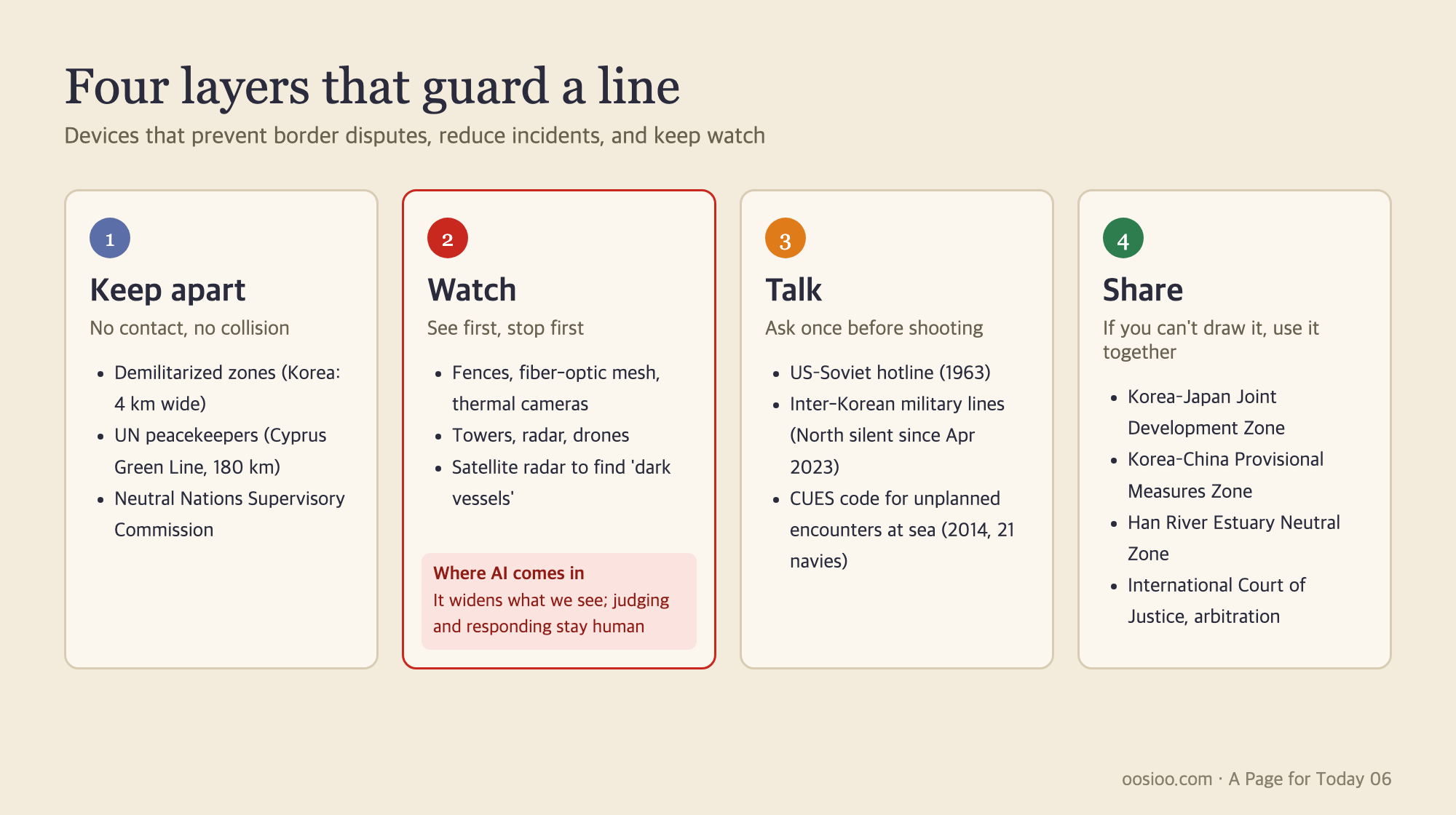
The first is keeping apart: putting land between two armies that no one enters. The DMZ is one example, as is the 180-km Green Line in Cyprus, guarded by UN peacekeepers since 1964. There's also the UN observer force that has stood between Israeli and Syrian troops on the Golan Heights since 1974. The Korean armistice system has its own Military Armistice Commission and Neutral Nations Supervisory Commission. Of the four neutral-nation supervisors present at the start, only Switzerland and Sweden remain today.
The second is watching: fences, guard posts, and cameras, now joined by sensors and satellites. This is the layer where AI, which I'll get to in the next section, is moving in.
The third is talking. On August 30, 1963, the year after the Cuban Missile Crisis, a direct hotline opened between the US and the Soviet Union. The first test message was the classic typing-test sentence, 'The quick brown fox jumps over the lazy dog.' There are similar arrangements at sea: in 2014 in Qingdao, China, navies from 21 countries including South Korea, the US, China, and Japan adopted the Code for Unplanned Encounters at Sea (CUES) — a kind of maritime etiquette specifying what signals to exchange when ships encounter one another. It has no legal force, but it creates a pause before a misunderstanding can escalate into an accident. North and South Korea also have a liaison line, but North Korea has stopped responding to it since April 2023.
The fourth is sharing: when a line can't be drawn, the space is simply left for joint use. The Joint Development Zone and the Korea-China Provisional Measures Zone are examples of this. The Armistice Agreement designated roughly 67 km of the lower Han River estuary as neutral waters, open to civilian vessels from both North and South. Ships rarely actually used it, but in 2018, for the first time in 65 years, the two Koreas jointly surveyed this waterway and found 21 reefs. It's a place where a river never became a border and instead stayed a shared stretch of water. When a dispute can't be resolved in the end, it gets handed to a third party like the International Court of Justice — as happened with both Essequibo and Preah Vihear.
When AI Stands at the Border
Watching is the layer being handed over to machines fastest.
In the mid-2010s, the South Korean military laid fiber-optic mesh along the fences of the General Outpost (GOP) line — the 'scientific surveillance system,' which sounds an alarm in the command post if the fence is cut or bent. It cost 170 billion won as of a 2014 report, and the military said it could cut troop numbers by 20%. But even after the machines arrived, people still slipped through. In 2012, a North Korean soldier defected by knocking on the door of a GOP barracks before anyone noticed him — the so-called 'knock defection.' In 2021, a defector in a wetsuit and flippers swam across and entered through a drainage culvert — the 'flipper defection.' After that, the military shifted toward having AI watch the camera feeds instead. In December 2024, an AI video-analysis system was installed for the first time at the 22nd Division's GOP and coastal units, and in April 2026 a plan emerged to cut GOP guard troops from about 22,000 to about 6,000 and fill the gap with AI surveillance. For a country with a shrinking military, leaning on machines is a hard choice to avoid. The same report also carried an expert's worry that the technology itself still has errors.
Along the US-Mexico border stand autonomous surveillance towers built by the defense startup Anduril: radar and cameras mounted on tall poles, with AI picking out people and vehicles and sending alerts. The 300th tower went up at the end of 2024, and US Customs and Border Protection (CBP) has committed $363 million to adding more than 200 additional towers with longer detection ranges. Terrain is a problem here too — the towers stand on hills and see only what's within line of sight. A September 2026 MIT Technology Review report described a death scene that a tower just 400-odd meters away couldn't see because a ridge blocked the view. The same report found that of 138 recorded deaths, more than 81 occurred within the sightline of towers unobstructed by terrain. Seeing and saving are not the same thing.
The most painful case is Israel's. The 'smart fence' surrounding Gaza was equipped with ground radar, cameras, and even remote-controlled weapons systems. On October 7, 2023, Hamas used cheap drones to disable the watchtowers and communications equipment first, then breached dozens of points simultaneously with bulldozers. Within Israel itself, there has since been soul-searching about having relied too heavily on technology.
Where AI actually shines brightest at the border is, in fact, the sea. A January 2024 paper by the Global Fishing Watch research team in Nature used deep learning to cross-reference satellite radar imagery with vessel position signals from 2017 to 2021. The result: roughly 75% of the world's industrial fishing vessels were 'dark vessels,' invisible to public tracking systems. The Korea Coast Guard is likewise expanding a system where AI analyzes footage shot by aircraft and helicopters to pick out illegal fishing boats. Across an ocean too vast for people to watch inch by inch, the machine sees first.
There's caution too. The EU once piloted an AI lie detector for airport immigration checks — an on-screen avatar inspector that read travelers' micro-expressions and assigned a risk score, a method criticized for having weak scientific grounding. Afterward, the EU AI Act classified AI used in immigration, asylum, and border management as 'high-risk.' AI at the border decides questions of life, death, and freedom of movement. That's exactly why it needs to be more accurate, and why it needs to be clearer who's accountable when it's wrong.
AI extends the watching layer, but it can't substitute for the other three. Judging what's been seen, deciding who to call, and deciding what to share — these remain human work.
If We Redrew Africa
Now let's carry the word from the notebook a little further. What if borders had been drawn well from the start? That question sharpens nowhere more than in Africa.
Look at a map of Africa and you'll notice an unusual number of ruler-straight lines. According to research by economists Alesina, Easterly, and Matuszeski, 44% of Africa's borders are straight lines. It's often said that European powers drew these lines at the Berlin Conference of 1884–85, but that's not quite accurate. Not a single African person was present among the 14 nations at the conference, but the conference itself only directly set borders in the Congo region. What the conference actually established was a rule for partition: whoever actually occupied a coastline and notified the other powers got to keep that land. Most of the lines were drawn afterward, over roughly two decades of bilateral treaties. British Prime Minister Salisbury put it this way at the time: "We have been engaged in drawing lines upon maps where no white man's feet have ever trod; we have been giving away mountains and rivers and lakes to each other, only hindered by the small impediment that we never knew exactly where the mountains and rivers and lakes were."
How those lines split people up is preserved in the numbers. Economists Michalopoulos and Papaioannou overlaid anthropologist George Murdock's 1959 map of African ethnic groups onto today's borders. Of the 825 groups analyzed, 229 — about 28% — were 'partitioned ethnicities,' with more than 10% of their territory cut off into another country. The Maasai, for instance, are split 62% in Kenya and 38% in Tanzania. And looking at conflict records from 1997 to 2013, regions inhabited by partitioned ethnic groups saw conflict that was roughly 40% more intense, and longer-lasting, than regions without them.
Independent African nations chose not to fix these lines. Organization of African Unity leaders, meeting in Cairo in 1964, resolved to respect the borders that existed at independence. The judgment was that fixing even one line would turn the whole continent back into a battlefield. Since then, only two countries have successfully seceded: Eritrea in 1993 and South Sudan in 2011. South Sudan, in turn, fell into civil war just two years after independence, in 2013. There's a counterexample too: Somalia is one of Africa's rare countries where language, religion, and culture are nearly uniform, yet once the state collapsed, clan warfare continued. Redrawing lines to match ethnicity doesn't guarantee peace.
Still, we can imagine. What would it look like if the lines were redrawn so that similar peoples each got as much contiguous land as possible? The tool I want to bring out here is the Voronoi diagram.
The Nearest Side Is Mine
Place a handful of points on a plane. Then give every point in that plane to whichever seed point is nearest. Each seed ends up with its own cell — this is a Voronoi diagram. The boundary between any two points becomes the perpendicular line running exactly through their midpoint, and these lines together form a patchwork of polygons.
The name comes from the Russian mathematician Georgy Voronoi, who defined this structure in general terms in 1908, but the underlying idea is older. A similar division appears in Descartes's 1644 diagrams of cosmic vortices, and Dirichlet treated it mathematically in 1850. In 1911, Alfred Thiessen of the US Weather Bureau grouped land with its nearest weather station to estimate average rainfall over a wide area — which is why geographers still call these 'Thiessen polygons' today. John Snow's line on his 1855 London cholera map works similarly: he connected the points where walking distance to the Broad Street pump equaled the distance to any other pump. Since that line was measured by actual walking distance through the streets, it's something like a distant ancestor of the 'terrain-aware Voronoi' I'll try out below.
Voronoi diagrams hide in more places than you'd think. Which cell tower a phone connects to, or which fire station responds to a call, is usually decided by proximity. When a robot navigates between obstacles, following Voronoi boundaries gives it the safest path — the one farthest from every obstacle at once. 'Lloyd's algorithm,' which repeatedly moves each point to the centroid of its own cell, is the prototype behind k-means clustering. It shows up in biology too: in 1974, ethologist Robert Barlow reported that the nest pits male Mozambique tilapia dig on the lake bottom press against each other to form polygonal territories. The denser the nests, the more hexagons appeared, but the single most common shape was the pentagon.
The same goes for people. Pedestrian studies measure crowd density by treating the area of a person's Voronoi cell as the space they occupy. In 1966, anthropologist Edward Hall divided interpersonal distance into four zones: within 45 cm is the intimate distance for lovers and family, 45 cm to 1.2 m is the personal distance for friends, 1.2 m to 3.6 m is the social distance for business, and beyond that is public distance. It varies by culture, but most of us get uncomfortable when a stranger steps inside that 1.2-meter radius. There's even a math paper that seriously examines whether choosing the urinal farthest from the door in a men's restroom is actually optimal. Voronoi diagrams are, in their own way, a language for describing how people spread out while keeping each other's space.
You can try three things yourself on the interactive board below.
People in a Plaza. When people walk in at random, even a small group ends up with someone standing inside someone else's 1.2-meter space. Press 'Step back' and everyone shifts slightly toward the center of their own cell — much like the way people in an elevator silently adjust their spacing. In this square, the limit for everyone to keep their 1.2 meters, standing in a honeycomb pattern, is about 48 people. Keep adding people, and eventually a point arrives where no amount of stepping back can preserve that space anymore. It's the same logic behind border disputes that ultimately erupt wherever land runs short.
Redraw Africa. Seeds are placed at the centers of 51 major ethnic and language groups, divided into Voronoi cells, with today's borders overlaid as dotted lines. The seed positions are only rough approximations lifted from textbook ethnic maps. Murdock's map actually contains more than 800 such groups, and real populations mix together and sometimes move with the seasons. Still, these cells are drawn based on where people actually live, which puts them in a different register from today's ruler-drawn borders. Drag a single seed and the boundaries of every neighboring cell shift entirely. The math for drawing a fair line is simple — what's far harder is deciding what to feed into that math: namely, who lives where.
Switch on 'Terrain' here, and cells divide by the effort of crossing instead of raw distance. Crossing high ground, steep slopes, or large rivers and lakes adds cost, and the land each seed can reach with the least effort becomes its cell. It's the same idea behind John Snow's line measured by walking distance through the streets. The boundaries then get pulled toward ridgelines and river courses, growing jagged and winding. On my screen, the share of boundary running along rivers, lakes, or steep slopes was 33% using distance alone, rising to 46% once terrain was factored in. Terrain clearly does pull a line toward it. But as we saw earlier, rivers move, watersheds and peaks don't always line up, and the same people often live on both banks of the same river. Following terrain doesn't settle the question — terrain, too, has to be interpreted by someone.
Median Line at Sea. Voronoi diagrams are, in fact, already used to delimit borders. Article 15 of the UN Convention on the Law of the Sea states that when two facing states can't reach an agreement, neither may extend its territorial sea beyond the median line equidistant from both coasts. That median line is exactly the boundary where cells belonging to different countries meet in a Voronoi diagram drawn from points along the coastlines. Toggle off 'Small-island points' on the playground and you'll see the line swing dramatically. Whether a single island or a single rock counts as a basepoint determines who owns the sea. The tensions around Dokdo and the five West Sea islands, and the race to build up islands on reefs in the South China Sea, all come from exactly this. It's also why the submerged reef of Ieodo can never serve as a basepoint.
A Line That Steps Back, One Pace at a Time
We've come a long way from a single word in a notebook. Looking back at the lines I've followed today, one thing becomes clear: a method for drawing lines fairly already exists. The Voronoi principle — that the nearest side is mine — is simple and applies equally to everyone. The problem was always somewhere outside that math: where to place the seeds, which islands to count, what to do when a river moves, and what to do with the decades of memory and blood already piled on top of a line that's already drawn.
The people in the plaza, without anyone directing them, each step back a little and so carve out their own cells. It doesn't matter who steps back first. Only once everyone gives a little ground does each person's own space actually appear. Isn't a border the same way? A buffer zone is the ground both sides gave up. A hotline is a device that asks one more question before the shooting starts. A joint development zone is a promise to share instead of drawing a line. No matter how far AI can see, it can't take that one step back on anyone's behalf.
And that's how A Page for Today starts from a single line in a notebook and arrives at one page of today's thinking.